Township
Parcel Map
We are working with Western Upper Peninsula Planning & Development Region (WUPPDR) to provide an online property map for the township.
The map overlay was created from an old 2 dimensional plat map overlaid on a 3 dimensional Google Earth view. The parcel boundaries are meant to be approximate; however the information contained was pulled directly from the Township property tax records.
To use the application you must first install Google Earth which is a free.
Free Download at http://www.google.com/earth/index.html
When you have Google Earth installed on your computer double click the following link:
ERT Map
Once the data file above has been downloaded to your computer you will need to Open or Launch the file see the map overlaid on Google Earth. Some Browsers will offer the choice to Open the file instead of Saving it, this will automatically load the information into Google Earth.
The first time you close the map it will ask if you want to save your Temporary Folder, click NO to delete the file or click Yes to make it available in Google Earth. If you click YES the parcel map will show up automatically each time you run Google Earth.
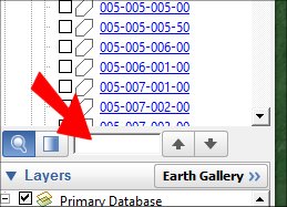
You can zoom in and click on any parcel for detailed information. You can also search for a parcel using the Parcel ID or the Owner by entering either in the search box as shown below. * Note - Use the Search Box in the middle of the page, NOT the one at the top. Check the box on the left to see detail for the requested property.

